
Self Tracking
Here is the actual, timestamped route of my recent trip east, as logged by my Wintec GPS datalogger.
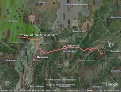
This nifty gizmo is a global positioning device with no screen and a single button for an interface. Once powered up, it takes a minute to acquire a signal lock and then logs my position to internal memory. Default is every five seconds, but I've dialed it back to 35 seconds to increase range (both battery power and storage capacity).
At the end of the trip the Wintec unit interfaces with my laptop via USB or Bluetooth (at least, the Windows-booting part of my laptop) and I can import the log files into Google Earth. My original intent was to share the Google Earth file, so everyone could play with it and see where I've been, but the Wintec device is too accurate: I really don't want to let the whole internet know which house is mine. Starting and stopping points, pulling over for gas, wrong turns... everything shows up just as if one had an eye in the sky.
I haven't used it for land mapping or geotagging yet, but I'm dying to.
posted by Erik @ 6/29/2006 07:06:00 PM
![]()
![]()
0 Comments:
Post a Comment
<< Home